Have you ever wondered what mysteries lie beneath the vast oceans covering our planet? As climate change and rising sea levels dominate headlines, understanding the Earth’s underwater landscape has never been more crucial.

Marine geology offers a fascinating window into the history and dynamics shaping our seabeds, revealing clues about natural disasters, resource deposits, and environmental shifts.
Join me as we explore this hidden world beneath the waves and uncover the secrets that could impact our future in surprising ways. Whether you’re a science enthusiast or simply curious, this deep dive promises insights that connect the ocean’s depths to everyday life.
The Dynamic Forces Shaping Our Ocean Floors
Tectonic Plate Movements and Seafloor Spreading
The ocean floor is far from static; it’s a dynamic landscape constantly reshaped by the movements of tectonic plates beneath the Earth’s crust. When two plates diverge, magma rises to fill the gap, creating new seafloor in a process known as seafloor spreading.
This continuous renewal can be observed at mid-ocean ridges, like the famous Mid-Atlantic Ridge, where vast underwater mountain chains form. I remember reading about how these processes contribute not just to the shaping of the ocean bed but also to triggering earthquakes and volcanic activity, which can have ripple effects on marine ecosystems and even coastal communities.
Understanding these forces gives us insight into both the past and future behavior of our planet’s geology.
Subduction Zones and Ocean Trenches
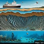
On the flip side, where tectonic plates converge, one plate often slides beneath another in a process called subduction. This leads to the formation of ocean trenches, some of the deepest places on Earth.
The Mariana Trench, for instance, plunges nearly 11 kilometers below sea level, a depth that boggles the mind. These trenches act as natural recycling centers where old crust is pushed back into the mantle.
From a practical perspective, subduction zones are also hotspots for seismic activity, including tsunamis that can devastate coastal regions. When I first learned about this, it struck me how these invisible undercurrents hold such immense power, quietly shaping the planet’s surface while influencing human safety.
Hydrothermal Vents: Underwater Oases
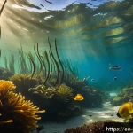
Near mid-ocean ridges and volcanic hotspots, hydrothermal vents spew mineral-rich water heated by underlying magma. These vents create localized ecosystems unlike anywhere else on Earth, thriving in complete darkness with life forms relying on chemosynthesis instead of photosynthesis.
I’ve always found it fascinating how these vents support unique organisms, from giant tube worms to exotic bacteria, showcasing nature’s adaptability.
Moreover, hydrothermal vents contribute to the chemical composition of seawater and can even influence global biogeochemical cycles. Their study not only reveals the resilience of life but also hints at the potential for life on other celestial bodies with similar environments.
Mapping the Ocean Floor: Technologies and Breakthroughs
Sonar and Multibeam Echosounders
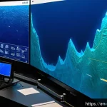
Mapping the vast and often inaccessible ocean floor relies heavily on sonar technology, which uses sound waves to measure depth and create detailed topographical maps.
Multibeam echosounders, an advanced form of sonar, emit multiple beams to cover broad swaths of the seabed at once, drastically improving resolution and accuracy.
In my experience exploring articles and documentaries on this, the leaps in sonar technology have been nothing short of revolutionary. They’ve allowed scientists to discover underwater mountain ranges, deep-sea canyons, and even shipwrecks previously hidden from view.
This detailed mapping is essential for everything from navigation safety to habitat conservation and resource management.
Satellite Altimetry and Remote Sensing
While sonar provides direct measurements, satellite altimetry complements it by measuring sea surface height variations caused by underwater features.
This technique estimates seafloor topography by detecting subtle gravitational anomalies. What’s remarkable here is how satellites orbiting hundreds of kilometers above Earth can infer the shape of the ocean floor below, providing global coverage in areas where ships cannot easily reach.
The integration of satellite data with sonar maps has created a more comprehensive picture of the ocean’s depths. I find this combination fascinating because it demonstrates how space-based technology directly informs our understanding of Earth’s hidden landscapes.
Autonomous Underwater Vehicles (AUVs)
The rise of AUVs has added a new dimension to ocean floor exploration. These robotic explorers can dive to extreme depths, collect samples, capture high-definition images, and even perform real-time analysis.
From what I’ve gathered, AUVs have been instrumental in venturing into previously unreachable trenches and hydrothermal vent fields, providing scientists with unprecedented data.
Using AUVs feels like sending remote-controlled submarines on secret missions, uncovering the mysteries of the deep without risking human lives. Their growing use promises even richer discoveries in the years to come.
Natural Hazards Hidden Beneath the Waves
Earthquakes and Tsunamis Originating Underwater
Underwater earthquakes, often triggered by tectonic shifts along fault lines or subduction zones, can unleash tsunamis—massive, fast-moving ocean waves that pose catastrophic risks to coastal areas.
The 2004 Indian Ocean tsunami remains etched in memory as a stark reminder of this danger. What surprised me is how quickly these waves can travel across entire ocean basins, sometimes reaching distant shores within hours.
Early warning systems rely heavily on understanding seafloor geology to predict such events accurately. This intersection of geology and public safety underscores the urgent need for continuous monitoring and research.
Underwater Landslides and Their Impacts
Submarine landslides occur when sediment accumulates on steep slopes until it becomes unstable and slides down, sometimes triggered by earthquakes or rapid sedimentation.
These events can displace huge volumes of water, generating localized tsunamis or damaging underwater infrastructure like communication cables. I once stumbled upon a case where an underwater landslide off the coast caused disruptions in internet services, illustrating how interconnected our daily lives are with seabed stability.
Understanding the triggers and locations of these landslides is crucial for mitigating risks, especially as coastal development and offshore industries expand.
Volcanic Activity Beneath the Sea
Volcanic eruptions don’t just happen on land; many occur on the seafloor, forming new islands or reshaping existing ones. Underwater volcanoes, often found near tectonic plate boundaries, can dramatically alter local ecosystems by releasing heat, minerals, and gases.
From what I’ve read, some submarine eruptions have even been detected through changes in water temperature and chemistry before the volcano becomes visible above the surface.
This ongoing activity reminds us that the ocean floor is alive with processes that affect not only geology but also marine life and human interests like fisheries and navigation.
Resources Buried in the Ocean’s Depths
Mineral Deposits and Their Economic Potential
The ocean floor harbors vast mineral wealth, including polymetallic nodules rich in manganese, cobalt, nickel, and rare earth elements essential for modern electronics and renewable energy technologies.
I recall being amazed by the sheer scale of these deposits scattered across abyssal plains. However, extracting these resources is technically challenging and raises environmental concerns.
Balancing economic benefits with ecosystem preservation is a delicate act, and ongoing research aims to develop sustainable mining practices. It’s a perfect example of how geology intersects with technology and ethics in shaping our future.

Hydrocarbon Reserves Beneath the Seafloor
Large reserves of oil and natural gas lie trapped beneath sediment layers on continental shelves and slopes. Offshore drilling has become a major industry, powering economies but also posing risks of spills and habitat disruption.
I’ve heard from experts that geological surveys and seafloor mapping are critical in identifying viable drilling sites while minimizing environmental impact.
Advances in seismic imaging have improved our ability to locate these reserves precisely, but the challenge remains to balance energy needs with conservation efforts, especially in ecologically sensitive areas.
Renewable Energy Opportunities from the Ocean
Beyond traditional resources, the ocean offers renewable energy potentials, such as offshore wind farms and tidal energy. Certain geological features, like underwater ridges and strong tidal currents, make some locations ideal for harnessing these clean energy sources.
From my perspective, integrating geological knowledge with engineering innovations is key to expanding sustainable ocean energy. This not only reduces reliance on fossil fuels but also creates new economic opportunities for coastal communities, emphasizing the value of understanding the seabed’s physical characteristics.
Environmental Changes Recorded in Seafloor Sediments
Climate History Encoded in Sediment Layers
Sediments accumulating on the ocean floor act as natural archives, preserving microscopic fossils, chemical signatures, and mineral deposits that tell stories about Earth’s climate history.
For example, analyzing oxygen isotopes in foraminifera shells reveals past ocean temperatures and ice volume changes. When I first delved into this topic, it amazed me how these tiny particles hold keys to understanding ice ages, warming periods, and even sudden climate events.
Such insights are invaluable for predicting future climate trends and guiding global policy decisions.
Human Impact on Marine Environments
Sediment cores also reflect human influences, including pollution, increased sedimentation from land-use changes, and ocean acidification. Traces of heavy metals, microplastics, and chemical contaminants accumulate over time, offering a timeline of anthropogenic effects.
I’ve found it sobering to see how our actions leave fingerprints deep beneath the waves, often far from direct observation. This evidence supports urgent calls for better environmental management and highlights the interconnectedness of terrestrial and marine ecosystems.
Biological Productivity and Carbon Sequestration
The type and amount of organic material in sediments provide clues about past biological productivity and the ocean’s role in carbon cycling. Areas with high productivity often accumulate organic-rich sediments that help sequester carbon for long periods, influencing global carbon budgets.
Learning about this process deepened my appreciation for the ocean’s critical function in regulating climate. Protecting these natural carbon sinks is essential, especially as we seek strategies to mitigate climate change impacts.
Human Exploration and Its Role in Ocean Science
Manned Submersibles and Scientific Expeditions
Human-operated submersibles like Alvin have played pivotal roles in exploring the deep ocean firsthand. The ability to observe seafloor features directly, collect samples, and conduct experiments on-site has yielded breakthroughs in marine geology and biology.
I recall watching footage from expeditions that revealed hydrothermal vents and bizarre deep-sea creatures, sparking widespread public interest. Such missions underscore the importance of human curiosity and technology working together to unveil the unknown.
International Collaboration and Data Sharing
Ocean exploration is a global endeavor, requiring cooperation among nations, institutions, and disciplines. Initiatives like the Seabed 2030 project aim to map the entire ocean floor by pooling resources and data.
This collaborative spirit enhances scientific understanding and supports sustainable ocean management. From what I’ve seen, these partnerships also foster innovation and capacity-building in developing countries, ensuring that the benefits of ocean knowledge are shared widely.
Challenges and Future Directions in Ocean Exploration
Despite advancements, exploring the deep ocean remains costly and technically demanding. Challenges include extreme pressure, darkness, and vast areas to cover.
However, emerging technologies such as AI-driven autonomous vehicles, improved sensors, and real-time data transmission promise to accelerate discoveries.
Reflecting on this, I’m excited about the potential to uncover new geological phenomena, resource deposits, and ecosystems that could reshape our understanding of the planet and inform how we protect it.
| Ocean Floor Feature | Formation Process | Significance | Examples |
|---|---|---|---|
| Mid-Ocean Ridge | Seafloor spreading at divergent tectonic plates | Creates new oceanic crust and underwater mountain chains | Mid-Atlantic Ridge, East Pacific Rise |
| Ocean Trench | Subduction where one plate slides beneath another | Deepest parts of the ocean, sites of earthquakes and tsunamis | Mariana Trench, Tonga Trench |
| Hydrothermal Vent | Heated water from magma interacting with seawater | Supports unique ecosystems and alters ocean chemistry | Black Smokers on Mid-Atlantic Ridge |
| Submarine Landslide | Collapse of sediment on steep slopes | Can trigger localized tsunamis and damage infrastructure | Storegga Slide (Norwegian Sea) |
| Volcanic Seamount | Underwater volcanic activity | Forms islands or reshapes seafloor topography | Hawaiian-Emperor Seamount Chain |
Conclusion
The ocean floor is a fascinating and ever-changing world shaped by powerful geological forces. From tectonic movements to volcanic activity, these processes not only sculpt the seafloor but also impact marine ecosystems and human societies. Advances in technology continue to unlock the mysteries hidden beneath the waves, deepening our understanding and inspiring responsible stewardship of this vital part of our planet.
Useful Information to Know
1. The Mid-Ocean Ridge is a key site of seafloor spreading where new crust is constantly formed, driving oceanic plate movement.
2. Ocean trenches, formed by subduction zones, are the deepest parts of the sea and hotspots for earthquakes and tsunamis.
3. Hydrothermal vents create unique ecosystems independent of sunlight, revealing life’s adaptability in extreme environments.
4. Modern mapping technologies like multibeam sonar and autonomous underwater vehicles have revolutionized ocean exploration.
5. Understanding underwater hazards such as landslides and volcanic eruptions is crucial for coastal safety and infrastructure protection.
Key Takeaways
Our ocean floors are shaped by dynamic geological processes including plate tectonics, volcanic activity, and sediment movements. These processes influence natural hazards, marine biodiversity, and resource availability. Technological advancements have greatly enhanced our ability to explore and monitor the seafloor, enabling better management of its resources and risks. Protecting these underwater environments requires a balance between economic interests and environmental stewardship, underscoring the ocean’s critical role in Earth’s systems.
Frequently Asked Questions (FAQ) 📖
Q: uestions about Marine GeologyQ1: What exactly does marine geology study and why is it important?
A: Marine geology focuses on the structure, composition, and processes of the ocean floor. It helps us understand how underwater landscapes form and change over time.
This knowledge is vital because it sheds light on natural hazards like tsunamis and earthquakes, guides the discovery of valuable mineral and energy resources, and informs us about past climate conditions.
By studying marine geology, we gain insights that can improve disaster preparedness and environmental conservation efforts.
Q: How does climate change affect the ocean floor and marine geology?
A: Climate change influences marine geology in several ways. Rising sea levels can submerge coastal areas and alter sediment patterns on the seabed. Ocean warming affects underwater currents and ecosystems, which in turn impact sediment deposition and erosion.
Additionally, melting polar ice contributes to changes in sea-floor pressure and can trigger underwater landslides. Understanding these effects helps scientists predict future changes in marine environments and assess risks related to infrastructure and habitats beneath the waves.
Q: Can marine geology provide clues about future environmental changes?
A: Absolutely. The ocean floor acts as a historical record, preserving layers of sediments that reflect past environmental conditions. By analyzing these layers, marine geologists can identify patterns of climate shifts, volcanic activity, and sea-level changes over thousands or even millions of years.
This information offers valuable context for current trends and helps forecast potential future scenarios. Personally, exploring sediment cores has revealed to me just how dynamic and interconnected Earth’s systems are, emphasizing the ocean’s role in shaping our planet’s future.