With growing concerns about climate change and ocean health making headlines, diving into marine geology has never been more relevant. Understanding the Earth’s underwater landscapes helps us unlock vital clues about our planet’s past and future.

In this hands-on guide, we’ll explore how fieldwork brings marine geology to life, revealing secrets hidden beneath the waves. Whether you’re a curious beginner or a seasoned enthusiast, join me as we embark on an exciting journey to uncover the dynamic processes shaping our ocean floors.
Let’s dive in and discover what lies beneath!
Exploring Ocean Floor Mapping Techniques
Sonar Technology and Its Evolution
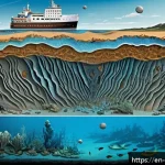
Sonar, or sound navigation and ranging, has been a game changer for marine geologists trying to visualize the seafloor. Early on, single-beam sonar provided a rough sketch of underwater terrain, but it was limited in scope and resolution.
Nowadays, multibeam sonar systems offer incredibly detailed, three-dimensional maps that reveal intricate features like underwater mountains, trenches, and sediment layers.
From my own experience on research vessels, the clarity and precision of multibeam data never cease to amaze me—each ping sends back a treasure trove of information that can be immediately analyzed on board.
This technology not only speeds up data collection but also helps scientists detect subtle changes in seafloor morphology that hint at geological activity or environmental shifts.
Satellite Altimetry: Seeing from Space
While sonar provides detailed local maps, satellite altimetry offers a broader perspective by measuring sea surface heights to infer underwater topography.
This method is especially useful for mapping remote or deep-ocean areas where ship surveys are impractical. By analyzing variations in sea surface height caused by gravitational anomalies, scientists can predict features like seamounts and trenches.
I’ve found this technique fascinating because it combines oceanography, geophysics, and remote sensing, allowing us to “see” beneath the waves without ever setting foot on a ship.
The integration of satellite data with sonar results creates a comprehensive picture of the seafloor’s shape and geological structure.
Comparing Mapping Methods in Marine Geology
To better understand the strengths and limitations of these techniques, here’s a detailed comparison:
| Mapping Method | Primary Tool | Resolution | Coverage Area | Best Use Case | Limitations |
|---|---|---|---|---|---|
| Single-Beam Sonar | Echo Sounder | Low | Narrow, linear tracks | Basic depth measurements | Limited spatial coverage, low detail |
| Multibeam Sonar | Multibeam Echo Sounder | High | Wide swaths | Detailed bathymetric maps | Costly equipment, requires ship time |
| Satellite Altimetry | Satellite Radar Altimeter | Moderate | Global | Large-scale topography | Lower resolution, indirect data |
Collecting and Analyzing Seafloor Samples
Core Sampling: Unlocking Geological History
Core sampling is a cornerstone of marine geology that allows scientists to extract cylindrical sections of sediment or rock from the seafloor. These cores act like time capsules, preserving layers of sediment that reveal clues about past climate, ocean currents, and tectonic events.
I recall participating in a coring expedition where each core brought back stories spanning thousands of years—visible layers of volcanic ash, changes in sediment grain size, and organic content all told a vivid history.
The process involves lowering a coring device through the water column, sometimes to depths of several kilometers, and carefully retrieving the core to prevent disturbance.
In-Situ Measurements and Their Importance
While samples provide physical evidence, in-situ measurements taken directly at the seafloor complement them by capturing real-time environmental conditions.
Instruments measuring temperature, salinity, pH, and current velocity help contextualize sediment data. During one dive, deploying a CTD (conductivity, temperature, depth) sensor gave us immediate feedback on water column properties that influenced sediment deposition patterns.
These measurements are vital for understanding ongoing processes like sediment transport, bioturbation, or chemical alteration, which all factor into interpreting marine geological records accurately.
Laboratory Techniques for Sediment Analysis
Once samples are back on shore, laboratory analysis begins with sieving, microscopic examination, and geochemical assays. Particle size distribution reveals the energy conditions of sediment deposition, while mineralogical studies identify the sources of sediments—whether they’re volcanic, biogenic, or terrigenous.
Isotope dating techniques, such as radiocarbon dating, provide absolute ages that anchor marine geological events in time. I’ve spent countless hours at the microscope, marveling at tiny fossil fragments that serve as biostratigraphic markers.
The combination of fieldwork and lab analysis creates a powerful toolkit for decoding Earth’s underwater archives.
Understanding Plate Tectonics Through Marine Geology
Mapping Mid-Ocean Ridges and Trenches
Mid-ocean ridges and deep-sea trenches are the stage where tectonic plates constantly interact. By mapping these features, marine geologists can track seafloor spreading and subduction zones.
I once joined a survey targeting the Mid-Atlantic Ridge, where the seafloor’s rugged topography and volcanic activity were on full display. Multibeam mapping revealed the ridge’s central valley and transform faults, while heat flow measurements indicated active magma chambers beneath.
These observations are crucial for understanding how new oceanic crust forms and how plates recycle back into the mantle.
Seismic Surveys and Earthquake Monitoring
Seismic reflection and refraction surveys send sound waves deep into the seafloor to image subsurface structures. This technique allows geologists to visualize sediment layers, faults, and magma chambers.
During a research cruise, we deployed air guns and hydrophone arrays to gather seismic data, which later unveiled hidden fault lines beneath the sediment.
Coupled with ocean-bottom seismometers that record earthquakes, these tools help scientists monitor tectonic activity in real time, providing early warning signs for tsunamis and other hazards.
Hydrothermal Vents as Windows Into Plate Boundaries
Hydrothermal vents, often found near mid-ocean ridges, are unique geological features where heated, mineral-rich water escapes from beneath the seafloor.
These vents support ecosystems thriving without sunlight and serve as indicators of ongoing volcanic and tectonic processes. On a submersible dive, witnessing these vents firsthand was unforgettable—the black smokers spewing mineral plumes looked like underwater chimneys.
Studying these systems helps marine geologists understand fluid-rock interactions and the role of hydrothermal circulation in crustal formation.
Using Remote Operated Vehicles (ROVs) in Marine Exploration
Capabilities and Advantages of ROVs
ROVs have revolutionized marine geology by allowing direct observation and sampling at depths unreachable by human divers. These robotic explorers are equipped with high-definition cameras, robotic arms, and sensors, enabling detailed surveys of underwater landscapes.
I remember piloting an ROV during a deep-sea expedition, maneuvering it over rocky outcrops and collecting rock samples with precision. The ability to control these vehicles remotely and gather real-time data greatly enhances the efficiency and safety of marine geological investigations.
ROV Missions: From Survey to Sampling
ROV missions typically combine visual surveys with targeted sampling. Before deploying an ROV, scientists plan specific transects to cover areas of interest such as seamounts, sediment plains, or fault zones.
During the dive, the ROV’s cameras stream live footage, allowing the team to identify geological features and decide where to collect samples. The robotic arms can grab rocks, sediment cores, or even biological specimens, providing a multidisciplinary perspective.
These missions often uncover unexpected discoveries, like rare mineral deposits or new species living in extreme environments.

Challenges and Innovations in ROV Technology
Despite their versatility, ROVs face challenges such as limited battery life, communication delays, and the complexity of operating in rugged terrain.
Innovations like tether management systems and improved autonomous capabilities are pushing the boundaries of what ROVs can do. In one recent mission, an ROV equipped with sonar mapping and chemical sensors was able to conduct multi-parameter surveys without direct human control, demonstrating the potential for extended, unmanned exploration.
These advancements promise to make marine geological fieldwork more productive and less dependent on weather or sea conditions.
Interpreting Marine Geological Data for Environmental Insights
Linking Seafloor Features to Climate Change
Marine geological data offers valuable clues about past and present climate dynamics. Sediment cores reveal historical ocean temperatures and ice volume changes, while seafloor morphology can indicate areas vulnerable to rising sea levels or erosion.
From my observations, features like submerged river channels and fossil coral reefs tell stories of shifting coastlines and ocean chemistry over millennia.
Understanding these patterns helps scientists predict how marine environments might respond to ongoing climate change and guide conservation efforts.
Assessing Human Impact on the Ocean Floor
Human activities such as deep-sea mining, trawling, and pollution increasingly affect the seabed. Marine geologists monitor these impacts by comparing baseline data with current observations.
For example, sediment disturbance from bottom trawling alters benthic habitats and sediment composition, which can be detected through repeat sonar mapping and sediment analysis.
During a field campaign, we documented changes in sediment texture near a mining site, highlighting the need for sustainable management practices. These insights are crucial for balancing resource use with ocean health preservation.
Predicting Geological Hazards in Coastal Zones
Coastal regions are particularly vulnerable to geological hazards like submarine landslides and tsunamis. Marine geological surveys help identify unstable slopes and fault zones that could trigger such events.
Combining bathymetric data with seismic activity records allows for risk assessment and early warning development. I’ve seen firsthand how detailed seafloor maps can inform emergency preparedness plans, potentially saving lives by forecasting tsunami wave paths and timing.
This practical application of marine geology underscores its importance beyond academic research.
Integrating Marine Geology with Other Ocean Sciences
Collaboration with Marine Biology
Marine geology and biology often intersect, as seafloor structures influence habitats and biodiversity. Coral reefs, hydrothermal vent communities, and sediment types all shape the distribution of marine life.
During joint expeditions, geologists and biologists share data to better understand ecosystem dynamics. For instance, sediment composition affects benthic organism settlement, while geological activity can create nutrient-rich environments.
This interdisciplinary approach enriches our knowledge of ocean systems and supports holistic marine management.
Oceanography’s Role in Marine Geological Studies
Oceanographic parameters like currents, temperature, and chemistry play a major role in sediment transport and deposition, key areas of study in marine geology.
Fieldwork often involves simultaneous collection of physical oceanographic data to contextualize geological findings. I remember coordinating with oceanographers during a cruise where real-time current measurements helped explain sediment distribution patterns we observed.
Integrating these disciplines enhances the accuracy and depth of marine geological interpretations.
Technological Synergies Driving Innovation
Advances in remote sensing, data processing, and robotics from various ocean sciences fuel innovations in marine geology. For example, machine learning algorithms developed for oceanographic data analysis are now applied to interpret complex seafloor maps and sediment characteristics.
The cross-pollination of technologies accelerates discovery and improves efficiency. Engaging with experts across fields has broadened my perspective and opened up new possibilities for tackling challenging marine geological questions.
Conclusion
Exploring the ocean floor through advanced mapping and sampling techniques has dramatically expanded our understanding of marine geology. The integration of technologies like sonar, satellite altimetry, and ROVs allows for detailed observation and analysis of underwater landscapes and geological processes. These insights not only deepen scientific knowledge but also support environmental protection and hazard mitigation efforts. As marine exploration continues to evolve, so will our ability to uncover the ocean’s hidden stories.
Useful Information to Remember
1. Multibeam sonar provides highly detailed 3D maps of the seafloor, crucial for identifying geological features and changes.
2. Satellite altimetry complements sonar by offering large-scale ocean floor topography from space, especially in remote areas.
3. Core sampling unlocks historical climate and tectonic data preserved in sediment layers, acting as natural archives.
4. ROVs enable safe, precise exploration and sampling at depths unreachable by divers, increasing research efficiency.
5. Combining marine geology with biology and oceanography enhances understanding of ecosystems and sediment dynamics.
Key Takeaways
Understanding ocean floor mapping and sampling methods is vital for studying geological processes and environmental changes beneath the waves. The strengths and limitations of sonar, satellite altimetry, and direct sampling highlight the importance of using complementary approaches. Technological advances in ROVs and data integration continue to push the boundaries of marine exploration. Ultimately, marine geology plays a crucial role in assessing climate impacts, human activities, and geological hazards, supporting informed ocean management and conservation.
Frequently Asked Questions (FAQ) 📖
Q: uestions about Marine Geology FieldworkQ1: What kinds of equipment are essential for marine geology fieldwork?
A: When heading out for marine geology fieldwork, having the right gear can make all the difference. Essential equipment typically includes sediment samplers like grabs or corers, underwater cameras or ROVs for visual surveys, GPS devices for precise location tracking, and water quality sensors to measure parameters such as temperature and salinity.
Personally, I found that using a combination of sonar mapping tools and sediment collection devices gave me the most comprehensive understanding of underwater landscapes.
It’s also wise to have safety gear and communication devices, especially when working offshore.
Q: How does marine geology fieldwork contribute to understanding climate change?
A: Marine geology fieldwork is crucial for decoding the history locked in ocean sediments and seafloor structures. By collecting and analyzing sediment cores, scientists can track changes in ocean chemistry and temperature over thousands of years.
These records help us see how past climate events unfolded, which in turn informs predictions about future trends. From my experience, witnessing these processes firsthand during field expeditions deepened my appreciation for how interconnected our planet’s systems truly are.
It’s like reading Earth’s diary, page by page, to understand the story of climate change.
Q: Can beginners participate in marine geology fieldwork, and how should they prepare?
A: Absolutely! Marine geology welcomes curious minds at all levels. Beginners should start by gaining a solid foundation in basic geology and oceanography through courses or online resources.
Hands-on experience is invaluable—joining university-led expeditions, volunteering on research vessels, or attending workshops can provide practical skills.
I remember my first field trip vividly; being open to learning and asking questions made a huge difference. Preparing physically for the demands of fieldwork and familiarizing yourself with safety protocols will also help you make the most of the experience.